Traffic Feasibility Analysis Results
The Traffic Feasibility Analysis concluded the following:
- The existing roadway with planned improvements will not provide enough capacity to support projected future traffic volumes in 2045 (20 + years beyond completion of construction).
- With no improvements, the existing roadway between Tekesta Drive and Preservation Road will reach capacity in 2035.
- Operational improvements are necessary to provide requisite capacity between N. Meridian Road and Preservation Road (Segment 1) and a four-lane roadway is necessary to provide requisite capacity to support future forecasted traffic volumes between Preservation Road and Tekesta Drive (Segment 2).
- Increases in vehicular capacity are necessary to provide for enhanced safety measures given a high percentage of rear-end crashes observed on the east end of the corridor.
Expansion of Bannerman Road, west of Tekesta Drive to N. Meridian Road, is warranted. A summary discussion of the results is provided below. For further details, please see Agenda Item No. 13 from the September 17, 2020 Intergovernmental Agency Board meeting and the Traffic Feasibility Analysis Report.
Bannerman Road Traffic Feasibility Analysis Segments
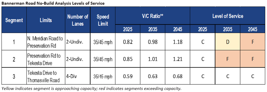
No-Build Analysis
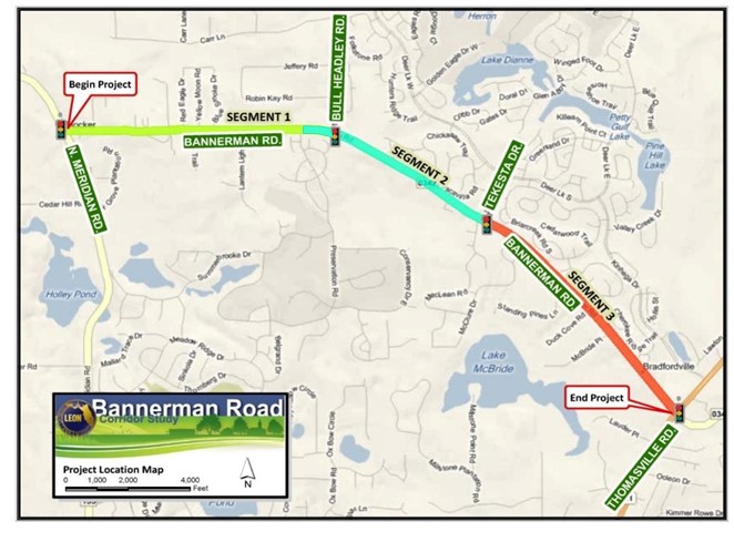
The Traffic Feasibility Analysis examined projected future traffic volumes on the existing roadway. The analysis of the existing corridor with only planned improvement is referred to as the “No-Build Scenario”. The No-Build Scenario consists of 4-lanes of traffic between Thomasville Road and Tekesta Dr., and incorporates the newly completed Orchard Pond Parkway. The analysis calculated the Level of Service (LOS) representing the degree of delay for each segment of the corridor to know if the existing roadway as enough capacity to support future forecasted traffic volumes. See the map above for roadway segment delineations.
The Traffic Analysis concluded that the existing roadway with planned improvements will not provide enough capacity to support projected future traffic volumes in 2045 (20 + years beyond completion of construction). Also – the roadway between Tekesta Drive and Preservation Road will reach capacity in 2035. Level of Service and Volume (V) over Capacity (C) ratio calculations are detailed in the following section.
Level of Service Calculation
Upon evaluation of the existing roadway configuration (No-Build), conceptual alternative configurations for roadway expansion were generated modeled for comparison with the No-Build alternative (defined below). This was done to evaluate the degree of expansion necessary in each segment of the roadway (see the map above) to achieve an acceptable level of service in the 2045 design year. The alternative roadway configurations were modeled with forecasted traffic volumes to determine a specific level of service for each alternative. To calculate the level of service for the roadway, the traffic volume (V) (as obtained from the future traffic volume projection) is divided by the capacity (C) ascertained from FDOT Generalized Level of Service Tables. If the ratio of V/C is greater than 1, the roadway does not have adequate capacity. If the V/C ratio is less than or equal to 1, the roadway is of adequate capacity. Further, if the V/C is greater than 1, then the LOS is F, defined as more traffic than the road can serve and if the V/C is less than or equal to 1, then the LOS is D or better, the roadway is considered to be at or under capacity. It is important to note that the modeled traffic volume of a particular segment will vary with configuration change to other roadway segments, thus affecting the levels of service. For example, if Bannerman Road is expanded to four lanes from Tekesta Drive to Thomasville Road, the traffic volume between N. Meridian Road and Bull Headley Road will change due to motorists choosing the expanded route.
Segment 1
Three roadway conceptual typical sections have been developed for Segment 1 (N. Meridian Road to Preservation Road):
- Alternative A: a 2-lane road with a median
- Alternative B: a 4-lane road with a median
- Alternative C: a 2-lane road (no median) with intermittent turn lanes where necessary.
Each conceptual alternative includes multimodal improvements, with a multi-use trail and a sidewalk. Also, each typical section includes a curb and gutter closed drainage system (no ditches) which minimizes right of way needs. The LOS calculated for each alternative within Segment 1 is presented in the table below.
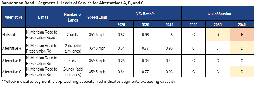
Based on model results, cost data, and right of way needs detailed in the Summary of Conceptual Build Alternatives Table below, the recommended improvement for Segment 1 is Alternative A, the 2-lane road with a median at an estimated construction cost of $15.9M.
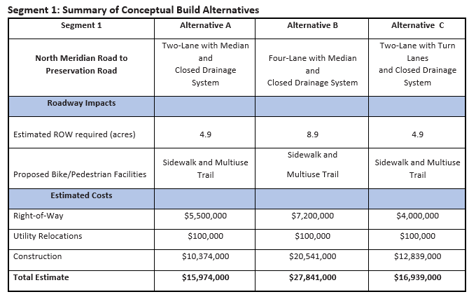
The safety provided for vehicles traveling along Segment 1 of Bannerman Road by constructing turn lanes within the median was taken into account in this recommendation. The proposed median turn lanes may reduce rear-end collisions. The proposed sidewalk and trail will increase pedestrian safety. The median will also provide aesthetic landscaping and vegetation along the corridor. Stormwater treatment for any approved expansion of Segment 1 will be accomplished by constructing a treatment pond.
Segment 2
Two roadway conceptual typical sections have been developed for Segment 2 (Preservation Road to Tekesta Drive):
- Alternative A: a 4-lane road with a median using a curb and gutter drainage system
- Alternative B: a 4-lane road with a median using an open drainage system (swales and ditches) as necessary.
Each typical section is flanked by a multi-use trail and a sidewalk. The LOS calculated for each alternative within Segment 1 is presented in the table below.
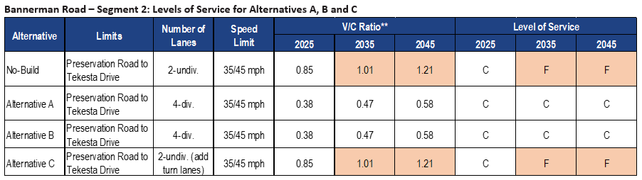
Based on model results, cost data, and right of way needs detailed in the Summary of Conceptual Build Alternatives Table below, the recommended improvement for Segment 2 is Alternative A, the 4-lane road with curb and gutter drainage at an estimated construction cost of $18.7M.
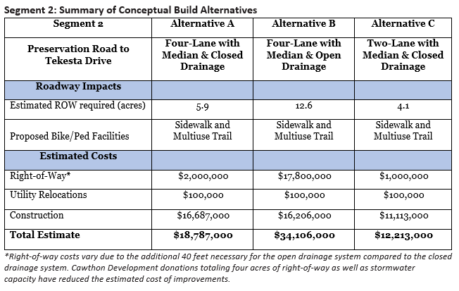
Alternative A alleviates the traffic capacity issues while providing the lowest cost alternative for Segment 2. The enclosed curb and gutter drainage system reduces the additional right-of-way needed to construct the roadway. Alterative A also avoids additional right-of-way requirements along the north side of Bannerman Road to the east of Bull Headley Road where there are several existing commercial developments. Along the south side of Bannerman Road, the Cawthon Development, through a development agreement with Leon County, has been working with Blueprint to donate a total of approximately four acres of right-of-way adjacent to the south side of Bannerman Road. Additionally, the Cawthon Development has agreed to provide stormwater capacity for the Bannerman Road improvements adjacent to the development in their on-site stormwater treatment facility. The aforementioned right-of-way donation and stormwater treatment capacity for the Bannerman Road improvements have reduced the anticipated cost of improvements to Segment 2. As with Segment 1, the proposed sidewalk and trail will increase pedestrian safety. The median will also provide aesthetic landscaping and vegetation along the corridor.
Traffic Feasibility Study Results are described in more detail in the links below.