The Bannerman Road Corridor Study continues previous efforts to improve Bannerman Road and consists of two steps, including a Traffic Feasibility Analysis to determine future traffic capacity needs along the corridor, and an update of the 2012 Final Engineering Report reflecting the findings and recommendations of Traffic Feasibility Analysis. The Traffic Feasibility Analysis was recently completed and approved by the Blueprint Intergovernmental Agency Board of Directors at their September 17, 2020 meeting. The Traffic Feasibility Analysis evaluated traffic and safety conditions along Bannerman Road from North Meridian Road to Tekesta Drive. The need to widen Bannerman Road from Thomasville Road to Tekesta Drive was previously determined by the 2012 Final Engineering Report, coordinated by Leon County. The purpose of the Traffic Feasibility Analysis was to determine if operational improvements or expansion (widening) of Bannerman Road is warranted, based on projected future traffic through 2045. The Traffic Feasibility Analysis is comprised of the following items:
- Traffic volume and safety analysis
- Preliminary cost estimate of alternative roadway configurations
The Traffic Feasibility Analysis concluded that to accommodate the future forecasted traffic volume, Bannerman Road is in need of additional capacity in the form of operational improvements (turn lanes) from North Meridian Road to Preservation Road and expansion from two to four lanes from Preservation Road to Tekesta Drive. The Board’s subsequent action as well as the study results can be found here.
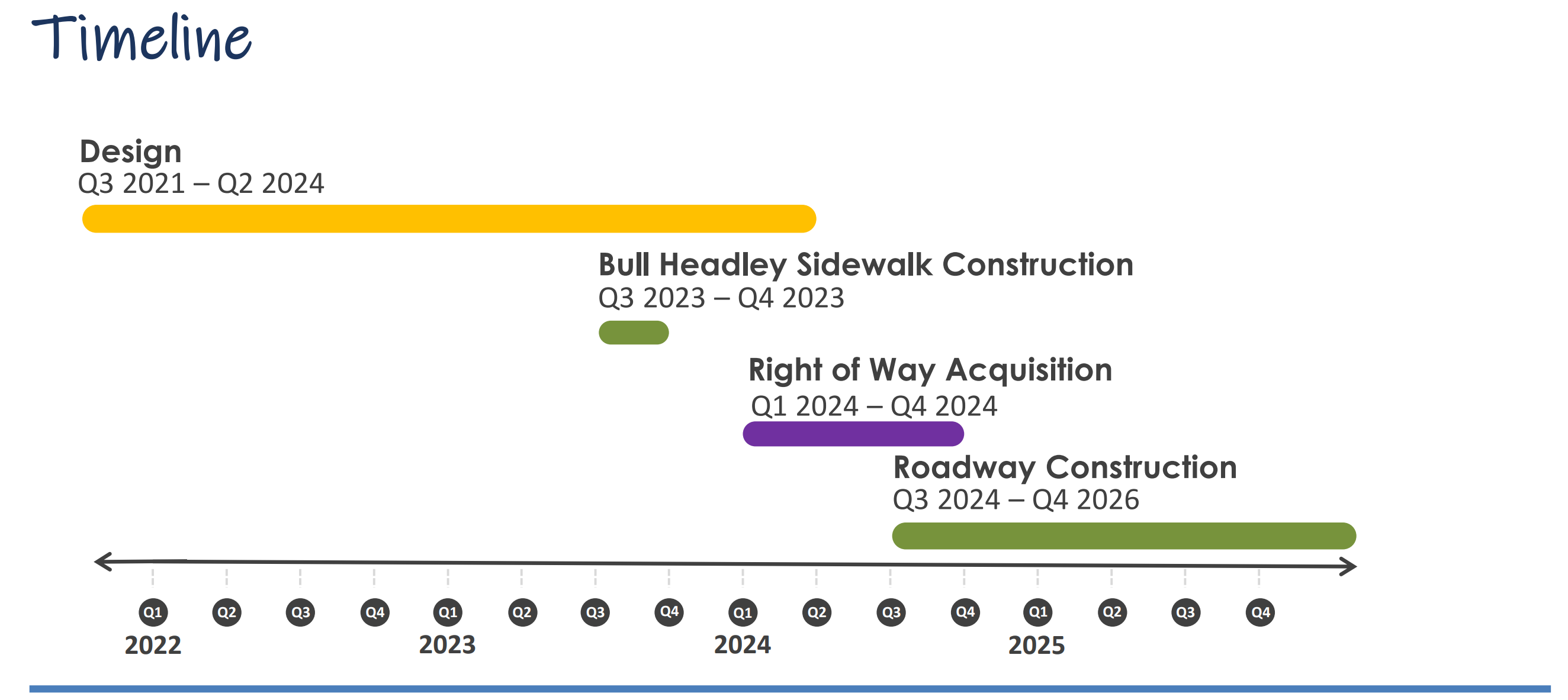
The update to the Final Engineering Report is scheduled to begin in the Spring of 2021. The project schedule is located here.
The need for additional capacity on Bannerman Road was originally identified in the 2012 Final Engineering Report for the corridor, completed in 2012 by Leon County, and was later included in the Capital Region Transportation Planning Agency (CRTPA) 2040 Regional Mobility Plan, which was adopted in November 2015. Subsequent to the 2012 Final Engineering Report the project was added to the Blueprint 2020 work program in 2014 by the Sales Tax Extension Citizens Committee with a project description of expanding Bannerman Road to four-lanes between Tekesta Drive and Thomasville Road and to construct a multiuse trail from Thomasville Road to N. Meridian Road.
In response to the need for the project, Blueprint’s Intergovernmental Agency Board (BPIA) requested a Traffic Feasibility Analysis in June 2019 to include the examine expansion of Bannerman Road west of Tekesta Drive to North Meridian Road. The action was taken to examine the viability of widening Bannerman Road due to increased commercial and residential development along the corridor through data gathering and future population forecasting. The results of the Traffic Feasibility Analysis are presented here.
Purpose
The purpose of the Northeast Connector Corridor Project is to improve regional mobility and enhance connectivity for motorized and non-motorized users. Operational improvements will provide additional traffic capacity in a holistic manner enhancing water quality, safety and aesthetics along the corridor. The addition of capacity on the roadway will ultimately ease traffic congestion between two arterial roadways in Thomasville Road and North Meridian Road.
Need
The project is needed to provide additional capacity along Bannerman Road to accommodate current and projected future population increases and to provide improved multimodal access and facilities, and safety improvements to reduce current crashes, between Thomasville Road and the scenic North Meridian Road.
For further discussion of the purpose and need for the project please see the Project Information page.
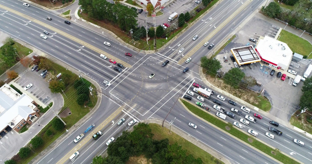
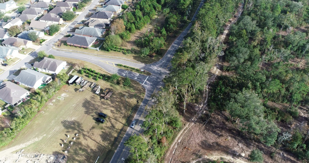
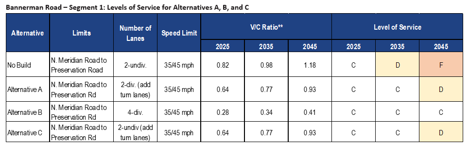
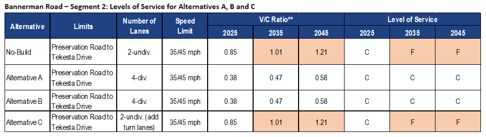
The Bannerman Road Traffic Feasibility Analysis is broken into two segments: Segment 1, from North Meridian Road to Preservation Road, and Segment 2, from Preservation Road to Tekesta Drive. A third segment, from Tekesta Drive to Thomasville Road, was not included in this Feasibility Study and is currently scheduled for expansion to 4 lanes. These three segments are shown in the Project Map below. This analysis focused on identifying areas where additional roadway capacity is needed by segment, to avoid adding capacity in areas where it is not needed. The results indicated operational improvements are necessary to provide requisite capacity between N. Meridian Road and Preservation Road (Segment 1) and a four-lane roadway is necessary to provide requisite capacity to support future forecasted traffic volumes between Preservation Road and Tekesta Drive (Segment 2). The results of the analysis were presented to and approved by the Blueprint Intergovernmental Agency Board on September 17, 2020. 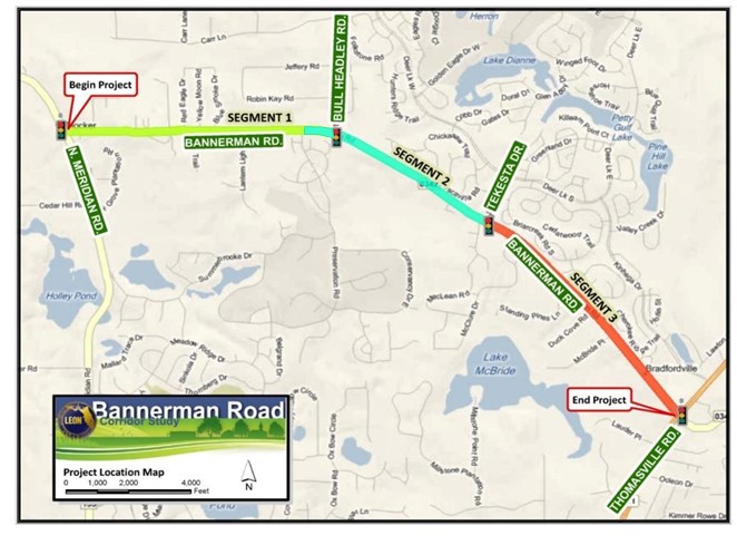
Yes. The need for bicycle and pedestrian facilities throughout the corridor was documented in Leon County’s 2012 Final Engineering Report for the corridor and in the CRTPA’s 2040 Regional Mobility Plan (RMP). This project will include bicycle and pedestrian facilities along Bannerman Road as follows:
- Quail Comon Drive to Bull Headley Road: 10-foot, paved multi-use trails on both the north and south sides of Bannerman Raod
- Bull Headley Road to Meridian Road: 10-foot, paved multi-use trail on the south side of Bannerman Road and a 6-foot sidewalk on the north side of Bannerman Road
The project is being funded by the Leon County-Tallahassee Blueprint Intergovernmental Agency through a one-cent local option surtax approved by Leon County voters in 2014. Learn more about eh Blueprint program and other projects funded by the penny sales tax at www.blueprintia.org.
The current estimated cost of the Northeast Connector Corridor: Bannerman Road project is $98.9 million, which will fund capacity and multimodal improvements along the four-mile corridor including the widening Bannerman Road to four lanes from Quail Common Drive to Preservation Road, and adding a median and multimodal enhancements along the entire corridor. Also funded through the Northeast Connector Corridor project are construction of two sidewalk projects: Tekesta Drive (Deer Lake to Bannerman Road) and Bull Headley Road (Chadwick Way to Boat Landing). Lastly, a 1.5 mile extension of the Orchard Pond Trail from meridian to the current trailhead will be completed through this project, as well as portions of the Meridian Greenway south or Orchard Pond Parkway.
Yes – The project will improve congestion along Bannerman Road.
The Traffic Analysis concluded that the existing roadway with currently planned improvements will not provide enough capacity to support projected future traffic volumes in 2045 (20 + years beyond completion of construction). Also – the roadway between Tekesta Drive and Preservation Road will reach capacity in 2035 as shown in the table below.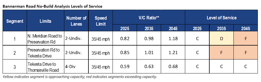
Traffic Model results for analysis of three different roadway configurations along Bannerman Road indicate relief of congestion (low levels of service) and thus, any authorized construction associated with the project should assist in the relief of congestion along Bannerman Road. See the tables below for calculated levels of service in the conceptual alternatives modeled. For further discussion of the Feasibility study Analysis results please see the 2020 Feasibility Analysis page.
Both motorized and non-motorized roadway network users. Upon authorization, the improvements will include additional capacity for motor vehicles as well as facilities for bicyclists and pedestrians, benefitting the entire community. Further, multimodal transportation corridors will be available to nearby neighborhoods, businesses, and future commerce centers throughout the corridor.
Additional information can be found on the Community Engagement page. Public comments will be accepted via the project website, and at all community meetings. You may also contact the Blueprint Project Manager Megan Doherty by phone at (850) 219-1060 or via email at megan.doherty@blueprintIA.org
There will be multiple opportunities to attend community meetings as well as provide feedback throughout the course of this project. All materials that are presented at meetings will be made available following the meeting on the project website under the Community Engagement page. In addition, questions and comments from the public can be shared with the project team at any time throughout the study by visiting the Contact Information page.
The Blueprint Intergovernmental Agency Acquisition Process is described in detail in this pamphlet.